Difference between revisions of "CSM:Usage"
From its-wiki.no
Seraj.Fayyad (Talk | contribs) (→Bus) |
Seraj.Fayyad (Talk | contribs) (→Bus) |
||
| Line 37: | Line 37: | ||
[[File:Average_emissions_of_CO2.png|600px|center|Average emissions of CO2]] | [[File:Average_emissions_of_CO2.png|600px|center|Average emissions of CO2]] | ||
| − | The sensor platform employed in the buses has been designed and developed by IA-ADN. The platform pumps air from outside the bus to a chamber in contact with the sensors through an 6 mm diameter tube located on the top of the bus. The chamber is located inside the bus. The air quality platform is connected with a computer system that collects data directly from the bus, such as, speed, position, use of breaking, etc. Using the General Packet Radio Service (GPRS), the air quality and driving pattern data, together with the position (GPS) information, are transmitted to a central database for storing, retrieving, aggregating, manipulating and presenting of the sensor data. | + | The sensor platform employed in the buses has been designed and developed by IA-ADN. The platform pumps air from outside the bus to a chamber in contact with the sensors through an 6 mm diameter tube located on the top of the bus. The chamber is located inside the bus. The air quality platform is connected with a computer system that collects data directly from the bus, such as, speed, position, use of breaking, etc. Using the General Packet Radio Service (GPRS), the air quality and driving pattern data, together with the position (GPS) information, are transmitted to a central database for storing, retrieving, aggregating, manipulating and presenting of the sensor data. The air quality sensor is mounted on the overhead lockers as it shown on the right, and it is connected with the CatedBox responsible of gathering the speed, time stamp and position of the bus among other variables related with the driving patterns. |
| + | |||
[[File:BusSensor.png|300px|right|Screenshot of the bus sensor package]] | [[File:BusSensor.png|300px|right|Screenshot of the bus sensor package]] | ||
| − | The sensor platform is monitoring NO<sub>2</sub>, CO, temperature and relative humidity. The system communicates data every 30 seconds. The sensor has been mounted in a diesel bus and in a Compressed Natural Gas (CNG). Below pictures show the location of the sensors in the bus CNG bus and diesel bus. | + | The sensor platform is monitoring NO<sub>2</sub>, CO, temperature and relative humidity. The system communicates data every 30 seconds. The sensor has been mounted in a diesel bus and in a Compressed Natural Gas (CNG). Below pictures show the location of the sensors in the bus CNG bus and diesel bus. |
[[File:SensorPakage-InGasBus.png|300px|right|Package location in gas bus]] | [[File:SensorPakage-InGasBus.png|300px|right|Package location in gas bus]] | ||
Revision as of 14:26, 28 April 2016
This page provides a short overview over usage examples from the Citi-Sense-MOB Toolbox. We have conducted real-life campaigns with users being cyclists, parents with children in kindergarten, bus companies, trafic wardens, and regular citizens.
Cyclists
In this example section we concentrate on the cyclist scenario. The Cyclist scenario is described in detail, as most of the aspects are similar also to the other scenarios,
- Application Scenario (from D4.5)
- Benefits
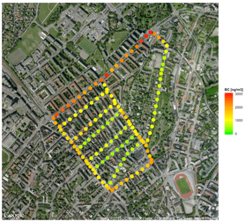
Results from the road trials with mobile platforms show that mobile monitoring can provide high spatial resolution data. Mobile monitoring can offer samples at “street level” which reflect exposures of individuals to air pollutants at ground level. The road trials have shown that the current challenge in employing low-cost sensors for mobile monitoring is the precision and accuracy of the low-cost sensors measurements. However when using more reliable instrumentation as for instance the portable microAeth black carbon monitor, high resolution air quality maps can be provided to users. Right hand figure shows a black carbon map obtained with sensors mounted on bicycles. The results show how concentrations change in shorter distances (meters), with the higher concentrations in the streets with more traffic and especially when standing in the traffic lights. Spatial map of black carbon concentrations monitored during a field campaign in Oslo using a portable microAeth carried by several cyclist. The data has been averaged using a 50 meter grid. The red colour represents higher concentrations and the green lower concentrations.
Picture from Eivind (he is cycling)
Track usage in mobile app
Kindergarten
In collaboration with CITI-SENSE 24 sensor units were tested and deployed in fixed locations in Oslo. The sensors distributed in 17 kindergartens and 7 locations in the city using for instance light poles. The sensor platform has been manufactured by GEOTECH (www.geotech.uk) and measures NO, NO2, O3, CO, Noise, Total Particle Count, Temperature, Relative Humidity and Atmospheric Pressure. The data is provided as hourly averages. The sensor platform has a lithium battery with capacity for approximately 6 months. The independence of power supply facilitates their location in areas where power supply it is not accessible.
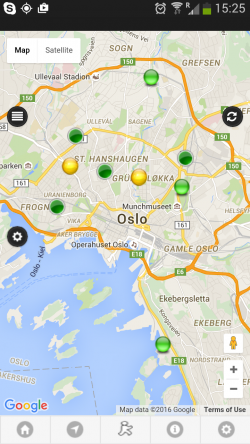
The air quality information is accessible from the web portal of the manufacturer, and NILU (one of Citi-Sense-Mob partners) has developed in the framework of the Citi-Sense-MOB project and algorithm to transmit the data from the GEOTECH services to the WFS Server. That will ensure all the data from the different sensors in located in the same WFS server (main server). From the WFS server sensors measurements are accessible and visualized by the "Sense City Air" app.
Regular citizens
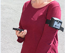
Some regular citizen have carried wearable sensors in Oslo. These wearable sensors measure 3 pollutant gases: CO, NO2 and O3, as well as temperature and relative humidity. The sensor platform communicates using Bluetooth with an Android phone. The GPS location is obtained from the phone. Other data as accelerometer data is also collected. These data is then sent to the WFS server (main server) when there is network available.
Bus
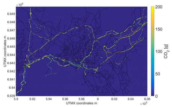
Two buses from the Oslo Nobina fleet were equipped with OBS and GPS to collect data on location, time stamp, speed and fuel consumption with temporal resolution of 1 second. One of the buses is a diesel-fuelled vehicle and the other uses Compressed Natural Gas (CNG). The buses cover and alternate between several line routes in Oslo offering a good spatial coverage of the urban area. The data from the OBS system allowed us to create traffic speed and CO2 traffic emission maps at city level, with unprecedented spatial resolution, as it appears within below figrue. If enough number of vehicles equipped with OBS are employed, it will be possible to estimate more accurately both the speed and the CO2 emissions from traffic at street resolution.
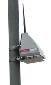
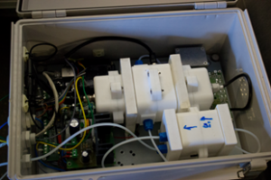
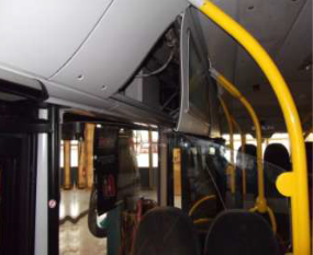
The sensor platform employed in the buses has been designed and developed by IA-ADN. The platform pumps air from outside the bus to a chamber in contact with the sensors through an 6 mm diameter tube located on the top of the bus. The chamber is located inside the bus. The air quality platform is connected with a computer system that collects data directly from the bus, such as, speed, position, use of breaking, etc. Using the General Packet Radio Service (GPRS), the air quality and driving pattern data, together with the position (GPS) information, are transmitted to a central database for storing, retrieving, aggregating, manipulating and presenting of the sensor data. The air quality sensor is mounted on the overhead lockers as it shown on the right, and it is connected with the CatedBox responsible of gathering the speed, time stamp and position of the bus among other variables related with the driving patterns.
The sensor platform is monitoring NO2, CO, temperature and relative humidity. The system communicates data every 30 seconds. The sensor has been mounted in a diesel bus and in a Compressed Natural Gas (CNG). Below pictures show the location of the sensors in the bus CNG bus and diesel bus.
The screenshots for bus sensor package on the right, shows the sensor platform electronics. The electrochemical sensors for NO2 and CO are located inside an air chamber where the air is pumped from outside. The chamber has an ozone filter to improve the performance of the sensor by reducing the cross-interferences between ozone and NO2. It has also a humidity controller to prevent the sensors to be exposed to extreme humidity that could damage them.
Lesson learned
We conducted an exhaustive evaluation of low-cost platforms. The evaluation included laboratory testing against reference instruments in a controlled environment and field testing against reference instruments (co-location) under a range of different environmental conditions (e.g., weather, traffic). The results show clearly that a good performance in the laboratory is not indicative of a good performance in outdoor real-world conditions. The coefficient of determination in laboratory was above r2>0.9 for all the gases, while in field it showed a significant decrease, especially for NO2 and O3. This decrease in the performance is most probably due to interferences with temperature and relative humidity. Advances in algorithms to process the data might result in a higher performance of the sensors. Results also showed a high variability in the sensor responses from the same sensor type, making necessary to characterize sensor by sensor, even if by the same producer.
The high variability in individual sensor performance, as well as the variability in the performance depending on weather conditions or changes in emission patterns, etc. makes low-cost platforms difficult to use for applications when high data quality is necessary (i.e. air quality surveillance for regulation purposes). Low-cost sensors is a promising technology, with a rapid evolution in the market and the performance of the sensors is improving. However, the sensors are still in a research phase that requires an exhaustive testing and comprehension of the performance of each individual sensor platform before they can be deployed.

