Difference between revisions of "DigI:Establish InfoSpot"
From its-wiki.no
Josef.Noll (Talk | contribs) m (→1. measure the available networks from the operators) |
Josef.Noll (Talk | contribs) m (→1. measure the available networks from the operators) |
||
| Line 15: | Line 15: | ||
== 1. measure the available networks from the operators == | == 1. measure the available networks from the operators == | ||
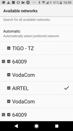
| − | [[has_Image::File:Network_search_Android.png| | + | [[has_Image::File:Network_search_Android.png|250px|thumb|left|''Figure 1: Results of Network Search, showing both the operators and the networks they provide'']] |
Open your Android phone | Open your Android phone | ||
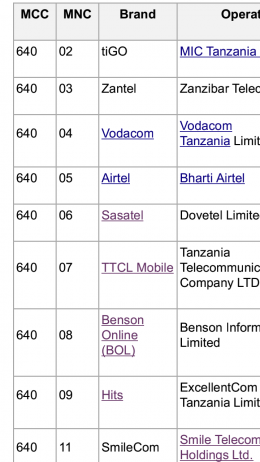
| − | [[has_Image::File:Network_Operators_TZ.png| | + | [[has_Image::File:Network_Operators_TZ.png|260px|thumb|right|''Figure 2: List of Network operators in Tanzania'']] |
* Goto '''Settings''' | * Goto '''Settings''' | ||
* Select '''Network & Internet ''' | * Select '''Network & Internet ''' | ||
| Line 23: | Line 23: | ||
* Select '''Network Operators''' | * Select '''Network Operators''' | ||
* Search '''Networks'''. It will take some minutes to show all networks. | * Search '''Networks'''. It will take some minutes to show all networks. | ||
| + | |||
| + | |||
| + | What you see is XXXXXXX | ||
| Line 28: | Line 31: | ||
<!--- [[File:Network_Operators_TZ.png|200px|left|thumb|''Figure 2: List of Network operators in Tanzania'']] ---> | <!--- [[File:Network_Operators_TZ.png|200px|left|thumb|''Figure 2: List of Network operators in Tanzania'']] ---> | ||
| − | |||
| − | |||
| − | |||
| − | |||
== 2. identify the direction of closest tower == | == 2. identify the direction of closest tower == | ||
Revision as of 11:33, 8 May 2019
| Digital Inclusion (DigI) | |||||||
|---|---|---|---|---|---|---|---|
|
Establish an Internet Lite Information Spot
Steps:
- measure the available networks from the operators
- identify the direction of closest tower
- measure field strength and technology
- create a map with buildings and distances
- purchase and configure the infrastructure
- installation on the site
Before you go out into the field, install a network analyser, e.g. Network Cell Info Lite (download from Google Play)
Note: this guide is made for Android 8.0. Functionality might look different
1. measure the available networks from the operators
Open your Android phone
- Goto Settings
- Select Network & Internet
- Select Mobile Network
- Select Network Operators
- Search Networks. It will take some minutes to show all networks.
What you see is XXXXXXX
2. identify the direction of closest tower
Note: your phone jumps to the best network. Thus, if you have a good 2G (GSM) network and a week 3G (UMTS) network, your phone will report from the 2G network. Thus, you need to fix your phone to the 3G (or 4G) network.
File:FixPhone to 3G.jpg
Select 3G (4G) as connection modus on your phone


